
Ziplines
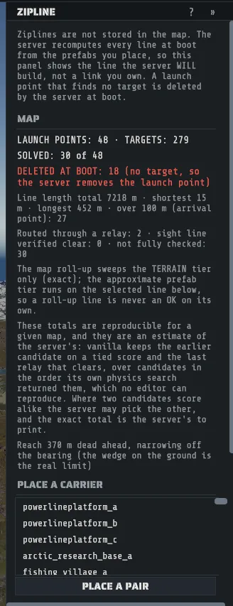
Ziplines are the one feature on a Rust map that you cannot place. The Zipline tool places the towers and platforms that carry them, as ordinary prefabs, aims each launch point, and then shows you the line the server is going to build from what you placed, including the cases where it will build nothing.
Press Z or pick Zipline on the tool rail. The status bar then reads:
LMB a launch or target · click a pair to test it · drag to aim · Alt+click swaps launch · Del removes · Esc steps backYour map does not contain a zipline. There is no zipline object to save. The server works out every line when it boots, from the carrier prefabs it finds, and a launch point that finds no target is deleted by the server: the tower stays standing and the line never existed. Everything this panel tells you is a prediction of that boot-time search.
Place a pair
Section titled “Place a pair”- Pick a carrier in Place a carrier. The list is the rideable carriers your content has.
- Click the ground to place it. It is snapped to the terrain, as one undo step.
- Or click PLACE A PAIR, then click the launch position and the landing position. The status
line says
now click the LANDING positionbetween the two clicks. Both carriers land in one undo step. - Click a launch handle in the viewport to select it and solve its line.
- Drag to aim the carrier. It turns about the vertical only, and the line re-solves live. A right-click or Esc while you are still dragging cancels the aim and turns the carrier back.
- Press Del to remove a carrier, Esc to step back out of whatever you are doing.
A platform carrier starts two lines, one in each direction. Alt+click swaps between them, and both deserve a look before you call it done.
Reading the panel
Section titled “Reading the panel”Map is the whole map, not the selection: how many launch points and targets exist, how many
solved, and DELETED AT BOOT, the count of launches the server will remove. If that number is not
zero when you are finished, that is a list of towers doing nothing.
Two things about those totals. While a map is still placing its prefabs the panel says
THE MAP IS STILL BEING PLACED and every count is a floor; it settles on its own, with no click from
you. And once settled, the totals are stable for a map (two looks read the same) but they are still an
estimate of the server’s: where two candidate targets score alike, the server’s own search can pick the
other one. The panel says as much under the totals, and the count that matters most, DELETED AT BOOT,
does not turn on that.
Selected launch names the answer: SOLVED, the target it picked, and the score it beat the others
with. Under it are the line’s real length along its sag, how many segments it has, how far it droops,
and whether it is long enough to get an arrival point. If nothing wins, the panel says
NO TARGET: the server DELETES this launch point at boot.
Candidates lists everything in reach, best score first, with a verdict chip on each row:
| Chip | Why that target is not the answer |
|---|---|
OK | It passes every test. The best-scoring OK row is the winner. |
LAUNCH CONE | It is too far off the direction the launch is aiming. |
TARGET CONE | The launch is too far off the direction the target faces. |
TOO HIGH | It sits more than 3 m above the launch. Lines only run downhill. |
TOO SHORT | The two are too close together. |
OUT OF RANGE | It is past the reach for that bearing. |
RELAY | It is a chain point, a pass-through rather than a destination. |
Click a row to test that pair and be told, in the game’s own terms, why the server does or does not pick it. Click AIM on a row to turn the launch at it.
Range is a wedge, not a circle
Section titled “Range is a wedge, not a circle”Reach is 370 m straight ahead and narrows as the target moves off the launch’s forward direction: at the edge of the cone it is about 74 m. The wedge Creator draws on the ground is the real limit, so trust it rather than the number.
Line of sight
Section titled “Line of sight”The line is checked in two tiers, and they are not equally good. The terrain check is exact, because
the ground is real geometry. The prefab check is approximate, because it uses each prefab’s bounding
box rather than its shape. So the readout is one of three things, and NOT CHECKED never reads OK:
| Readout | What it means |
|---|---|
LINE OF SIGHT: OK | Both tiers ran and both were clear, with the clearance measured. |
BLOCKED | Something is in the way. The message says whether that was the exact terrain check or the approximate prefab one, and where. |
NOT CHECKED | A tier could not run, so no answer is being claimed either way. |
When a line is blocked, the panel offers a relay at the point where the least lift is needed to clear the obstruction: PLACE THE RELAY HERE, one click, one undo step. A relay routes around something; it does not extend range. When a pair is simply too far apart, the offer is an intermediate platform at the middle of the line instead: PLACE THE PLATFORM HERE.
Confirm it on a server
Section titled “Confirm it on a server”This panel predicts; the server decides. Once your map is
running on a server, with admin rights,
ziplinelaunchpoint.report prints how many ziplines exist plus their total and average length, and
ziplinelaunchpoint.highlight draws an arrow along each one. If the editor and the server disagree,
the server is right.