
Channels, cut water through your map
A channel is open water cut clean across the map. It is not a bay or an inlet: it runs from one edge to the other and severs every landmass in its path, so one cut turns a continent into two islands with a real strait between them.
That makes it the fastest way to add water to a map you already like. The land, the mountains and the coastline you rolled stay exactly where they are, and the water is cut through them.
Open the tool
Section titled “Open the tool”Channels is its own tool, the square button to the right of the brush buttons in the toolbar. Click it, or press L.
A small dock opens over the map, the same way the brush docks do. Opening Channels closes whichever brush was open, and pressing Escape closes it again.
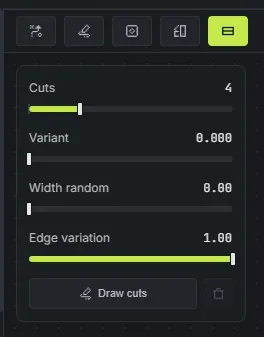
The sliders
Section titled “The sliders”Every one of these starts at nothing, so a map only gets channels when you ask for them.
- Cuts (0 to 16, default 0): how many channels cross the map. Because a cut is global, the count means the same thing on a one-island map and a thirty-island one. Start at 1 or 2 for a map split into a few big pieces, go higher for a broken, waterway-heavy world.
- Variant (0 to 1, default 0): slides the cuts to a different layout without touching your seed, the same way Shape variant rerolls an outline. Use it when you like the map but not where the water runs.
- Width random (0 to 1, default 0): spreads the widths apart. At 0 every cut is the same size. At 1 the spread runs from a hairline creek to nearly double the base width, so some cuts almost close over while others open into wide straits.
- Edge variation (0 to 1, default 1): how ragged the banks are. At 0 a cut has two straight sides. The default gives it bays, headlands and peninsulas along its length, so it reads as a natural waterway rather than a canal.
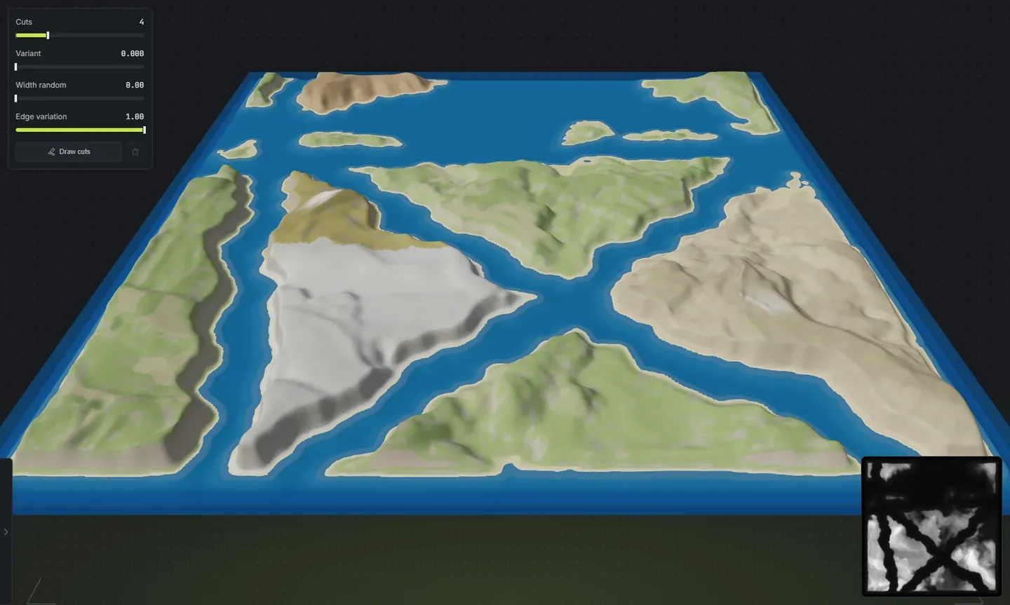
Draw your own channels
Section titled “Draw your own channels”Draw cuts opens a pad showing your real map, and you draw the water on it by hand.
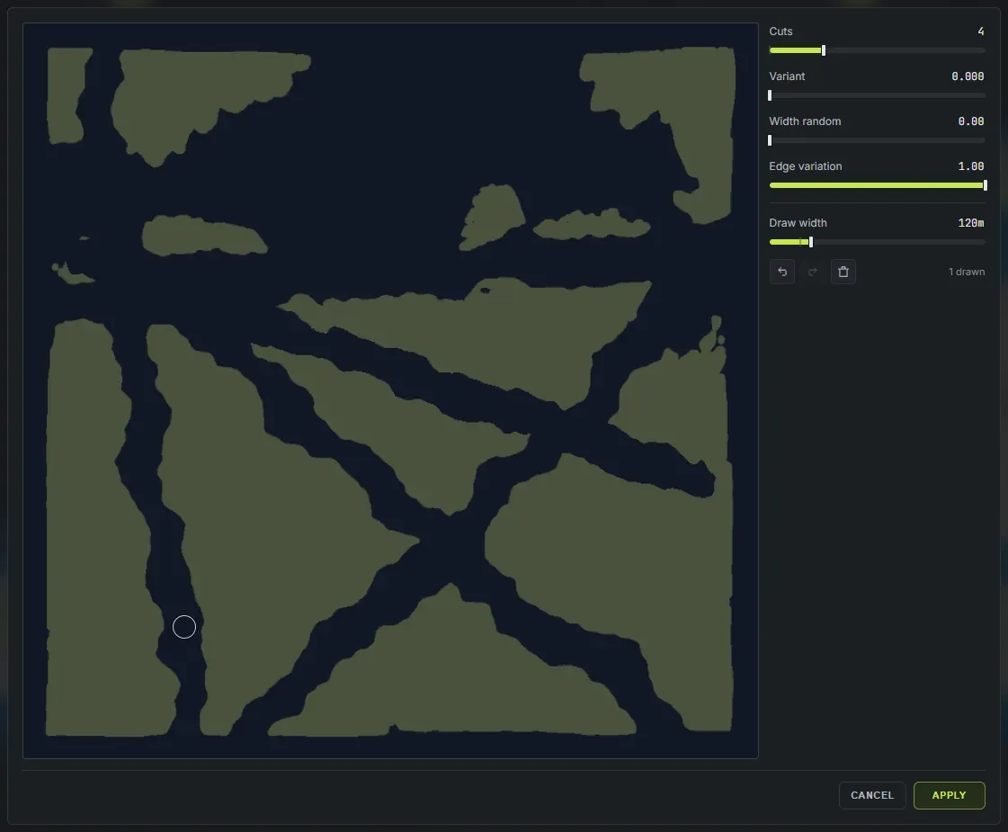
- Left-drag cuts a channel. It follows your line, with the same banks and the same edge variation a rolled cut gets.
- Right-drag puts the land back. It is an eraser for the channels you painted, so it only ever removes water you added, and it cannot invent land that was never there.
- The ring on the cursor is the width the next stroke will be.
Under the canvas, Draw width sets that width in metres, from 5 up to 600, so it means the same thing whatever size your map is. [ and ] nudge it while you draw.
The same four sliders sit beside the canvas, so you can roll cuts and draw them without closing anything. Width random and Variant reach your hand-drawn cuts too: they re-roll how wide each stroke comes out, and Variant also reshapes the banks. Neither one moves the line you drew.
The pad’s own keys: Ctrl + Z and Ctrl + Shift + Z undo and redo a stroke, Enter applies, Escape cancels. None of the app’s shortcuts fire while it is open, so a bare letter cannot conjure a new map out from under your drawing.
Apply commits what you drew. Cancel throws it away.
Drawn and rolled cuts live together
Section titled “Drawn and rolled cuts live together”Anything you draw is added to the cuts the sliders roll, never instead of them. You can roll two straits, then hand-draw the one creek you actually wanted in the north.
Your drawn strokes are part of the map’s settings, so they survive a conjure or a salt reroll: the land re-rolls underneath and your channels stay where you put them. The button beside Draw cuts discards the hand-drawn ones and leaves the rolled ones alone.
Make a cut belong to its island
Section titled “Make a cut belong to its island”A drawn cut normally sits on the map, not on the land it crosses, so moving an island afterwards slides it out from under its own channel. Bake drawn cuts into the islands fixes that: each stroke is handed to the island it cuts, and from then on the cut moves, turns and resizes with that island. Nothing about the terrain changes when you bake, and a baked cut can no longer slice a neighbour it never touched.
Rolled cuts stay on the map by design, since they are a property of the map rather than of any one island.
What a channel does to the rest of the map
Section titled “What a channel does to the rest of the map”Channels change the terrain itself, not just the picture. That means they carry into everything downstream with no extra work:
- The exported
.mapfile and the RAW heightmap. - The in-game view, where you can fly the strait and see the scale of it.
- The worldgen: the water in a cut is real ocean, with the Ocean and Oceanside topology layers to match, so Rust treats it as sea and not as a hole in the ground.
- A very thin stroke will not always sever land. The terrain passes that run after the cut average a narrow notch back up, so on a 3800 m map you need roughly 20 m of width before a channel reliably opens all the way through. Width random and a second pass over the same line both help.
- Draw the line you want and leave the raggedness to Edge variation. Trying to draw the wobble by hand fights the bank noise that is already there.
- If you want water between separate landmasses rather than through one, full multi-island maps roll that shape from the start, and Channels still works on top of it.
Next steps
Section titled “Next steps”- Generate the world so the new shorelines get their biomes, splats and topology.
- Export your map and open it in RustEdit.