
Map tools
Five operations that rewrite the entire map at once: turn it, rescale it, change how detailed its
terrain is, grow or shrink its border, and paste another .map into it. Open them with
TOOLS > Map Tools: Rotate, Resize, Merge….
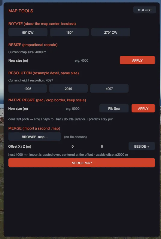
Each operation applies to the terrain, the prefabs and the paths together, and each one is a single undo step, however much it changed. Nothing is written to disk until you save.
“Resize” and “Native resize” are different operations and are not interchangeable. Resize rescales the whole world, so features keep their relative positions and get bigger or smaller. Native resize keeps the scale exactly and adds or removes border, so features keep their real size and their world position. Picking the wrong one is the mistake this panel invites.
The five operations
Section titled “The five operations”| Section | What it does to the map |
|---|---|
ROTATE (about the map center, lossless) | Turns everything a quarter, half or three quarter turn about the center. The terrain grids are permuted rather than resampled, so no detail is lost, and prefabs and path nodes turn with the ground. |
RESIZE (proportional rescale) | Stretches or shrinks the whole map to a new size in meters, about the center. Terrain resolution is unchanged, the coastline shape is preserved, and prefab and node positions scale with it. Prefab heights and prefab scales do not change, so monuments stay real size and nothing leaves the map. |
RESOLUTION (resample detail, same size) | Keeps the world size and changes how many terrain points describe it, resampling every layer so they stay registered. Prefabs and paths do not move. |
NATIVE RESIZE (pad / crop border, keep scale) | Holds meters-per-terrain-point constant and adds or removes border cells. The interior keeps its size and its world position, so prefabs never move. |
MERGE (import a second .map) | Pastes another map into this one at an offset. |
Rotate, resize, resample
Section titled “Rotate, resize, resample”- Click 90° CW, 180° or 270° CW to turn the map.
- For a rescale, type meters into New size (m) under
RESIZE (proportional rescale)and click APPLY. - For detail, click 1025, 2049 or 4097 under
RESOLUTION (resample detail, same size). The panel shows the current resolution above the buttons and asks you to confirm, because it rebuilds every terrain layer. - For border, type meters into New size (m) under
NATIVE RESIZE (pad / crop border, keep scale), pick Fill: Sea or Fill: Edge for how a grown border is filled, and click APPLY.
Native resize cannot land on any number you like. Terrain resolutions are fixed steps, so holding the scale constant limits the sizes it can reach, which works out to roughly half and double. The panel snaps your number to the nearest reachable size and shows you that size before you confirm, so read the confirm text rather than assuming you got the number you typed. A crop also removes prefabs that fall outside the new bounds, and the confirm text says so.
- Click BROWSE .map… and pick the second map.
- Type an offset into Offset X / Z (m), or click BESIDE→ to drop the import clear of the host map instead of on top of it.
- Click MERGE MAP.
Inside its own footprint, the imported map replaces the host: height, ground textures, biome and
water are overwritten by it, topology bits are combined, and a hole in either map stays a hole.
Outside that footprint the host is untouched. Its prefabs and paths are appended, prefabs that spill
past the host edge are dropped with a count, and path names are made unique so its River 1 does not
collide with yours.
The two maps do not have to be the same size or the same resolution: the paste samples the source in world space, so it lands at the right scale either way.
While it runs
Section titled “While it runs”A 4097 point grid is large, and there are six layers of it, so these operations are computed a few frames’ worth of rows at a time instead of freezing the window. You get a progress dialog with a percentage, and CANCEL (Esc) stops it.
Canceling is clean: the work is staged into private buffers and only applied when every layer has finished, so a canceled operation applies nothing at all and leaves no half-changed map to undo.
One honest edge, on rotate only: if the live ground textures are not at the same resolution as the
terrain they sit on, the rotation cannot write them back safely, so it rotates everything else and
reports ⚠ splat skipped (resolution mismatch) in the status line. The terrain is turned and the
ground textures are not, so repaint them or undo, rather than saving over your map.