
Import a heightmap
Creator reads a raw 16-bit heightmap (.raw), the interchange format World Machine, Gaea, World Creator,
Photoshop and Crucible Heightmap all write. It brings in the shape of the land and nothing else: no
biomes, no topology, no ground textures, no prefabs. Those you generate or
paint afterwards.
If you are coming from Crucible Heightmap, export a .map instead and you keep all of those layers. See
From Crucible Heightmap to Creator.
Import it
Section titled “Import it”- Open a map, or press CREATE BLANK on the start screen at the size you want. The heightmap lands on the terrain that is already there, so the map has to exist first.
- Choose the Sculpt tool.
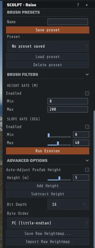
- Open Advanced Options in its panel.
- Set Bit Depth to match your file. 16 is almost always right.
- Set Byte Order. PC (little-endian) for a file written on Windows, Mac (big-endian) for the other convention. If the terrain comes in as violent noise, this is the setting that is wrong.
- Press Import Raw Heightmap and pick the file.
The toast tells you what it read: the source resolution, and the resolution it resampled to when the two
differ. It is one undo step, so Ctrl+Z puts the old terrain back.
The import replaces the whole heightmap, not part of it. There is no blending and no region. If you want part of another terrain, that is a stamp, not an import.
Sizes and resolutions
Section titled “Sizes and resolutions”Two different numbers matter and it is easy to confuse them.
| Number | What it is |
|---|---|
| Map size | How many meters the map spans along one edge, 1000 to 6000. This is what you set when you generate or create the map. |
| Terrain resolution | How many height samples the map stores along one edge. More samples means finer detail at the same size, and a bigger file. |
Your .raw file has no size in it at all: it is a square grid of height values, and Creator works out its
side length from the file’s own byte count. So the file does not decide the map’s size; the map you imported
into does.
If the file’s grid is a different side length from the open map’s terrain, Creator bilinearly resamples it to fit, which is silent and lossless in the direction that matters (a smaller source is stretched, a larger one is averaged down). To choose the resolution deliberately instead, set it before you import: TOOLS > Map Tools: Rotate, Resize, Merge…, the RESOLUTION (resample detail, same size) section, which offers 1025, 2049 and 4097.
Drizzza’s map sizes and resolutions is the reference for which combinations are worth using, and it applies whichever tool exported the file.
What to do once it is in
Section titled “What to do once it is in”The terrain is there and everything else is empty. In build order:
- Fly it once and fix what the import brought in: a plateau where you wanted a peak, a ridge in the wrong place. That is sculpting.
- Generate everything else on it in Creator Mode. Open TOOLS > Procedural Generation… and switch to
CREATOR MODE (the panel is already there, with a line saying why, when your land is not shaped like Rust’s
own island), and This map’s terrain is already picked in the LAND section. Creator measures the
land before anything runs and shows what it found. Two findings come up often with an exported heightmap,
and each has a one-click fix that is one undo step:
- Almost all land. A file whose sea sits at its lowest value comes in as one big continent. SET SEA LEVEL picks the height that becomes the shoreline and moves the terrain to match, with a preview of the new coastline.
- Land at the map edge. Rust needs open water around the map. SINK THE MAP EDGE lowers the outer margin smoothly to the seabed.
- Choose your monuments, and, if the land is a group of islands, the bridges and roads between them, then press >> RUN IN CREATOR MODE <<. The biomes, topology, ground textures, monuments, roads, rivers and rail are all worked out from your shape. The whole flow is on Procedural generation. If you would rather lay the layers down by hand, paint them yourself.
- Then paths and dressing, as in the build order.
You can also skip the Sculpt tool entirely: Creator Mode’s LAND section has its own Import a heightmap (.raw) choice, with the same Bit Depth and Byte Order, and picks This map’s terrain once the file is in.
Bare terrain spawns nothing. Rust decides what trees, ore and animals appear from the biome and topology layers, so an imported heightmap with no layers on it comes up as empty ground in game. Drizzza’s Rust biomes and topology explained is the page on why.
Exporting a heightmap back out
Section titled “Exporting a heightmap back out”The same panel writes one: Save Raw Heightmap… exports the open map’s terrain as a .raw at the
current terrain resolution, using the same Bit Depth and Byte Order you set above. It opens a save
dialog in the open map’s folder with a name that says what the file contains, for example
heightmap_2049x2049_16bit_pc.raw, so the file name carries the settings another tool needs. Keep the name
or pick your own; a toast names the file once it is written.
That is the route for taking a shape into a terrain tool and back. It carries the shape only, in both directions.