
The map overview
The overview is your map seen from above, drawn the way the in-game map draws it, with your roads, rivers, monuments, labels and markers on top of it. It is how you check that a map reads as a place rather than as a heightfield, and it is what you export when you want a picture of the map to show someone.
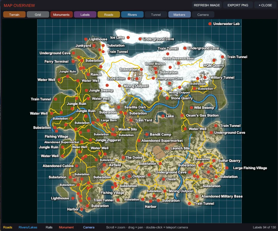
Open it with Tab, with VIEW > Map Overview, or with its button on the tool rail.
Move around it
Section titled “Move around it”| Input | What it does |
|---|---|
| Scroll | Zoom. |
| Drag | Pan. |
| Double-click | Teleport the camera to that spot on the map, so you can go and look at what you just noticed. |
The layers
Section titled “The layers”Nine toggles run along the top of the window. Each one is remembered between sessions.
| Toggle | What it draws |
|---|---|
| Terrain | The baked base image: the ground itself, colored by its real ground textures, shaded for relief and tinted by water depth, the same way Rust draws the map you see in game. |
| Grid | The lettered and numbered map grid. |
| Monuments | A dot per monument. |
| Labels | The monument name beside every monument dot, at every zoom, the way the in-game map names them. |
| Roads | Roads, trails and rails. Roads draw amber and rails gray. |
| Rivers | Rivers and lakes, in blue. |
| Tunnel | The underground train tunnel network. Off by default, and empty on a map that has none. |
| Markers | Your own map markers. |
| Camera | A wedge showing where the viewport camera is standing and which way it faces. |
The legend along the bottom names the colors for roads, rivers and lakes, rails, monuments and the camera.
The labels
Section titled “The labels”Every monument on screen gets its name, at every zoom level. The names are white, bold and outlined, so they read over snow, sand and rock alike, and they grow a little as you zoom in.
Where monuments sit close together, Creator moves a name rather than dropping it, and keeps a little clear space between any two names so they never touch: it tries the right of the dot, then the left, then above, then below, and then one size down. Only when a name has nowhere left to go is it hidden, and the legend says so, on the right: labels 81 of 84 means three monuments in the frame could not be fitted. Zoom in and they come back, because the dots spread apart as you do.
A monument is named the way the game names it. One that carries no in-game name is named after its prefab instead, so no monument on your map is ever left blank. A map label, the kind community maps place to name an area, reads its own text, the way the game draws it. A monument you gave a map name shows what players will see: your name alone where the game shows none, and the game’s name followed by yours where it shows its own.
Keeping it current
Section titled “Keeping it current”The base image is baked from your live terrain, so it works the same on a generated map and on one you opened, and it is cached: Creator re-bakes it when the terrain actually changes rather than on every open. If you ever doubt what you are looking at, REFRESH IMAGE forces a fresh bake and says so in the status line.
It is drawn by Rust’s own map-rendering rules, so a map you look at here reads like the same map would on a server: the same ground colors, the same relief shading, the same blue that deepens with the water, and monuments named the way the game names them rather than by their prefab filename.
The same image is what the start screen shows on its recent-map cards, and it does not need you to open the map first: a card with no picture yet is drawn from the map file itself, in the background, one map at a time, while you are looking at the list. A map that cannot be read keeps its plain placeholder rather than holding the screen up. Your newest map’s picture also fills the start screen behind the buttons; a blank map, whose picture is one flat color, leaves the default backdrop there instead.
Export a PNG
Section titled “Export a PNG”EXPORT PNG writes a 2048 by 2048 image next to your map, named after it with -overview
appended, for example my-island-overview.png. The status line prints the full path it wrote.
The export burns exactly the layers you can see. Turn the labels on if you want labels, turn the camera wedge off if you do not want an arrow in the picture, then export. The layers are rendered at full export size rather than scaled up from the window, so the labels are sharp and the picture does not depend on how big the window was.
A map you have not saved yet has nowhere of its own to write to, so its export goes into Creator’s
own data folder as map-overview.png. Save the map first if you want the image beside it.
If the export cannot run, the status line says why rather than failing silently: Export failed: no map rendered. means there is no map loaded to draw.